Integrating Remote Sensing with Physical Models to Map Inundation and Capture Methane Emissions
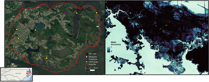
Biogeochemical processes are strongly influenced by hydrology, particularly in low-lying coastal wetlands where drastic changes in inundated and hydrologically connected areas occur over short time scales. Wetlands are known to be hotspots of methane emissions, with inundation acting as an “on/off” switch for methane production. However, current remote sensing inundation products are neither spatially nor temporally sufficient for quantifying ephemeral inundation and its subsequent methane emissions. Moreover, satellites alone are likely to underestimate inundation under dense forest canopies and during times of cloud cover. To address this, we propose to map daily inundation at high spatial and temporal resolution in North Carolina’s coastal wetlands by integrating multi-sensor remotely sensed data and physically based models in a model-data assimilation framework. Doing so will improve methane flux estimates and generate more accurate under-canopy estimates of inundation. We hypothesize that previous approaches have underestimated the hydroperiod across space, and by estimating at finer spatial and temporal resolution, this work will reveal small-scale, ephemeral inundation to be a key missing component of the wetland methane budget. This project addresses the following key objectives:
- Objective 1: Develop a multi-source remote sensing model for inundation classification
- Deliverables: a machine learning model that integrates optical and synthetic aperture radar (SAR) imagery to classify inundated pixels whenever satellite observations are available.
- Objective 2: Assimilate remote sensing inundation with PIHM-Wetland hydrologic model
- Deliverables: daily maps of inundation at 10 m resolution from 2016–2022, with uncertainty between remote sensing and PIHM-Wetland weighted by canopy cover to improve under-canopy estimates of inundation and validated with in-situ water table data.
- Objective 3: Estimate methane fluxes with Wetland-DNDC biogeochemical model
- Deliverables: simulated methane emissions using 10 m daily inundation probabilities versus using coarser resolution products input to Wetland-DNDC, with an interpretation of how these results influence the current understanding of wetland methane emissions.
This project will directly explore how water and biogeochemical cycles interact and ultimately how they affect global environmental change.
Jenna Abrahamson
she/her/hers
PhD Candidate, 2021-2025
Geospatial Analytics PhD Candidate within the SEAL lab at North Carolina State University.