An Operational Multisource Land Surface Phenology Product from Landsat and Sentinel 2
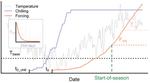
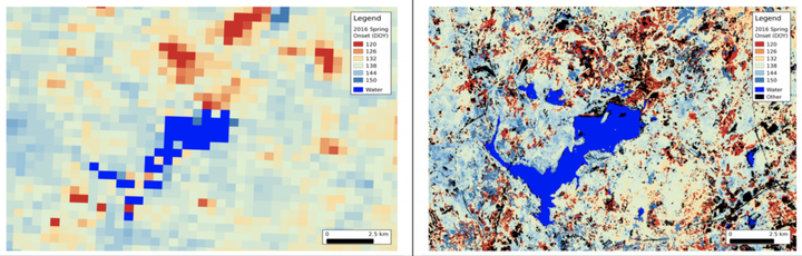 LSP from MODIS (left) and HLS (right). Generated by E. Melaas and M. Friedl
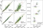
Funded by NASA. PI: Mark A. Friedl, Co-PI: Josh Gray
Land surface phenology (LSP) products, which synthesize the timing of phenophase transitions and quantify the nature and magnitude of seasonality in remotely sensed land surface conditions, provide a simple and intuitive way to reduce data volumes and redundancy, while also furnishing rich feature sets that are useful to a wide range of applications including ecosystem and agro- ecosystem modeling, monitoring the response of terrestrial ecosystems to climate variability and extreme events, crop-type discrimination, and land cover, land use, and land cover change mapping. Methods to monitor and map phenology from coarse spatial resolution instruments such as MODIS are mature and operational. However, the spatial resolution of MODIS is inadequate for many applications. The goal of this proposal is to create an operational land surface phenology product based on blended time series of Landsat 8 OLI and Sentinel 2A and 2B MSI data. We propose to generate our product at continental scale for North America at 30-meter spatial resolution using the Harmonized Landsat-Sentinel (HLS) data set that is being generated by NASA, and to distribute our results via the Land Processes DAAC.
Publications