Wuhan City Closed because of the Coronavirus, A Nighttime Light Change View
This must be the most difficult Chinese New Year for decades.
Since late December, the outbreak of respiratory illness caused by a new coronavirus – first identified in Wuhan, Hubei Province, China – has infected more than 30,000 people with more than 500 deaths. Unfortunately, no effective treatment has been found yet.
To prevent further spread of the disease, the Chinese government announced it would quarantine the whole city of Wuhan, with more than 11 million residents. Started from Jan 23, all public transportation in Wuhan has been closed, and strict health checks and permissions are needed for people who want to go in or out. Understandably, travel between Wuhan and its surrounding cities has drastically decreased.
By quickly analyzing the remotely sensed VIIRS Nighttime Light (NTL) satellite imagery (500 m spatial resolution), we saw a significant change pattern of this shutdown policy effect.
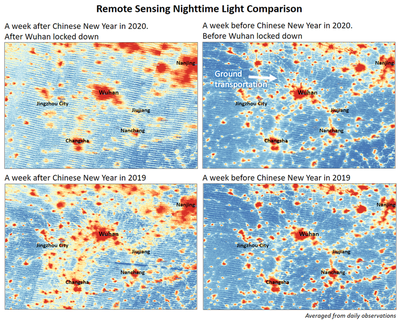
In the figure, colors show the intensity of NTL observations. The blue color indicates the background and the red color indicates the intensity of nighttime light signals. All images showed here are averaged from daily NTL observations to remove noise and cloud effects. The small lines connecting relatively big red clusters are showing ground transportations. After Wuhan was locked down, the signals from ground transportations have decreased significantly, including roads connecting Wuhan and other surrounding cities.
To better evident this year’s phenomenon, we also composed the same NTL observations from last year (the bottom two images) as a comparison. As we can see, last year, because of the Chinese New Year festival, people were moving frequently among cities during that time.
While this is just a quick look rather than a scientific research case, it can bring us some inspirations of using remote sensing to monitor and evaluate this disease control policy. Hope this disease will be defeated very soon.
Xiaojie Gao
he/him/his
PhD Candidate, 2019-2023
PhD candidate at Center for Geospatial Analytics, North Carolina State University.